Three Canyons Ride
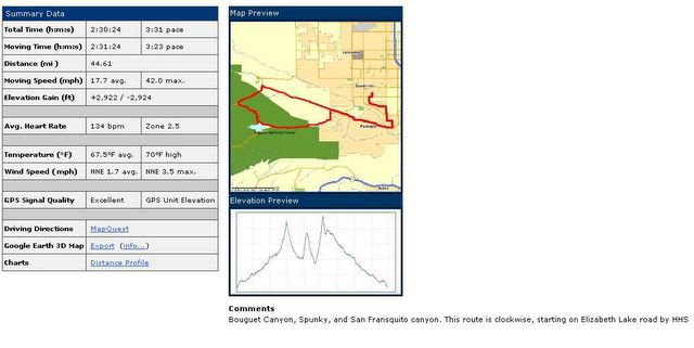
One of my favorite rides in the Antelope Valley is what the local bike riders call the “Three Canyons Ride.” The three canyons are Bouquet, Spunky, and San Fransquito Canyon. The way I like to go involves over 2900’ of elevation gain in 44 miles. Check out the profile of the ride below:

3 Canyons
If you’re familiar with my blog than you already know that I’m not exactly a superb hill climber by any stretch of the imagination. All the more reason to throw in a tough hill climb workout and the Three Canyons fits the bill. The hard way to ride the ride is in the clockwise directions, and to get to the first canyon you need to get yourself on Elizabeth Lake Road. This morning I choose to take 25th street, past Highland High School, and make the “long” approach. At other times, I might travel over Godde Road, and toss in another hill. But this approach also places me on Elizabeth Lake Road, around 11 miles up the road from 25th street. Elizabeth Lake is a great country road that climbs steadily until you reach Bouquet Canyon Road which branches off to your left. Bouquet Canyon will take you 24 miles south to the city of Santa Clarita, where the 14 freeway and the 5 freeway meet, home to Valencia and Magic Mountain. The only thing that mars Elizabeth Lake Road is the traffic. At times, on this road, you would swear you’re on a road in a suburb of Los Angeles – 50 miles to the south.
You turn left onto Bouquet Canyon Road and after a short down-hill stretch, you start your first of three climbs. It’s not a killer climb, 650’ in 5 miles; just enough to get your heart rate up to zone 3. After the climb you have a great downhill that almost makes you wish you’re going to continue to Santa Clarita but soon, on your right, Spunky Canyon road branches off – I swing right. With Bouquet Reservoir on your left you ride a relatively level stretch of a mile or two but soon see the steep switchbacks that await you. Spunky is short but steep with several switchbacks climbing up through the chaparral type vegetation. The climb is pure 7-10% and 11-12% briefly flickers across my Garmin’s display. But again, the climb is short and you’re now faced with a fast descent with a couple of hairpin turns. I love the descent but it is technical and not a time to completely relax after the 2nd main climb. Gravel and rocks on the road also keep you on “your toes” as you dive through the steep turns. The final turn to the left puts you right on top of the town of Green Valley but it hardly registers as you sweep through town at the speed limit of 35 mph. Even if I didn’t have my Garmin or my computer, I know my speed as local law enforcement has set up one of those radar displays that tells me, from the side of the road, just how fast I’m traveling.
You exit town and again turn right onto San Fransquito Canyon Road – the last of the Three Canyons. And this is the tough one – you don’t have to tell that to the many riders I’ve seen walking their bikes to the top of this climb. This climb actually sneaks up on you as the ride is very straight, due north. It starts pretty easy and then becomes an 8-9% steady climb for a couple of miles. The slight jag to the East keeps the top of the climb just out of sight and the route flirts with a 11-13% grade in short sections. Couple this with a headwind and you’ve got yourself with a pretty good climb and workout. I’ve never had to walk my bike up this section and today I’m riding it very well – holding at least 8-10 mph all the way to the top. I crest over the top and set up for the short screaming downhill that quickly drops you back to Elizabeth Lake Road. Now it’s 18 miles down the rolling hill road and back to Quartz Hill via either Godde Road or 25th street – today I choose 25th street and back the way I entered.
You can’t ask for a better training ride. You get 44 miles of climbs, descents, and rolling hills. You get a lake, mountains, and even a stream – in fact during the winter rains you get to cross about 5 streams on this ride. Check out the ride at MotionBased.com.
posted by Bob Grove at 11:11 PM
![]()
![]()